Marked by an orange line, this restricted area constitutes approximately 11% of Gaza’s land beyond the “Yellow Line,” which indicates territory occupied by Israeli forces since a ceasefire in October. The overall restrictions effectively cover nearly two-thirds of Gaza’s land.
The Israeli military shared these maps with aid organizations in Gaza around mid-March, according to two sources from those organizations, but has not made them publicly available.
Israel claims that the space between the orange line and the yellow truce line—where its troops withdrew under an October agreement—is designated as a restricted zone for humanitarian aid delivery, requiring coordination with the military. The military states that civilians are not impacted.
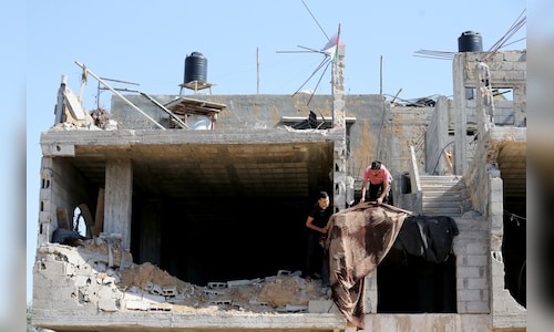
This enlarged area has raised alarms among displaced Palestinians residing there, who fear becoming targets for Israeli attacks. Concerns have also intensified about the possibility of Israel maintaining control over the region indefinitely.
Israeli authorities refer to the regions they have taken in Gaza, Syria, and Lebanon as “buffer zones” intended to prevent potential militant assaults following the October 7, 2023, assault led by Hamas that ignited the ongoing conflict in Gaza.
“In Gaza, more than half of the Strip’s territory” is under Israeli authority, Netanyahu stated in a video released on March 31. “We are the ones who attack and initiate, and we are the ones who surprise our enemies.”
’PEOPLE DON’T KNOW WHAT IS WHAT’
Israel’s expanding control beyond the line established in the US-brokered October ceasefire further complicates President Donald Trump’s plan for Gaza, which has been delayed due to the Iran conflict and disagreements regarding the disarmament of Hamas.
This also extends the territories in which Israel’s military asserts it can operate and take lethal actions against Palestinians without clearly defined boundaries. The October ceasefire line was marked by yellow-painted concrete blocks, which Israel has reportedly moved deeper into Hamas-controlled areas, according to Reuters.
In its first public remarks regarding the expanded zone, COGAT, the Israeli military body managing access to Gaza, stated that it has defined regions next to the Yellow Line where international organizations, including humanitarian groups, must coordinate their operations with the military.
“The boundaries of these areas (the Orange Line), where coordination is essential, are established and modified based on operational assessments, aiming to facilitate humanitarian efforts while protecting personnel in a complex operational context,” COGAT explained.
COGAT did not respond to inquiries about how often it updates and shares maps with aid groups showing the orange line or if it has informed Palestinian civilians of its location.
Since mid-March, at least three Palestinians working with international aid organizations—two from UNICEF and one from the World Health Organization—have been killed in Israeli strikes in the area between the two lines.
In these incidents, Israel’s military claimed to have identified threats near the Yellow Line and acted accordingly. UNICEF and WHO did not immediately reply to requests for comment regarding whether they coordinated their workers’ activities with Israel.
Rani Ashour, a resident of a camp for displaced individuals near Gaza City situated between the two lines, noted that families were lacking water and other aid because aid organizations were reluctant to send staff to the area.
“People don’t know what is what; the (orange) line may shift overnight,” he said.
Since the ceasefire, local medics report that Israeli fire has claimed the lives of over 800 Palestinians in Gaza, many of whom were in areas adjacent to the Yellow Line dotted with camps for displaced persons and bombed-out structures. Four Israeli soldiers have died during this same timeframe.
NEW MAP APPEARS TO SHOW SHIFTING LINES
The two aid sources, both operating in Gaza, indicated that the military had initially provided a map showing an enlarged zone beyond the Yellow Line post-ceasefire. This map was disseminated by organizations like UNICEF but not by the military itself.
In mid-March, the military sent out an updated map indicating the Yellow Line and marking the expanded area with an orange line, according to the sources, who have shared images of the map with Reuters but preferred not to have them published. The new map delineates that the Yellow Line has progressed to include the original expanded zone, while the orange line outlines the perimeters of an even larger restricted area.
When asked about the movement of the Yellow Line, the military declined to comment but stated that the “area adjacent to the Yellow Line is a sensitive and dangerous operational environment,” adding that “signs are displayed indicating it is forbidden to approach.”
This effectively allows Israel to control at least 64% of Gaza, according to Jad Isaac, director general of the Applied Research Institute-Jerusalem, an independent Palestinian research organization in the occupied West Bank. This leaves the nearly 2 million inhabitants largely confined to a narrow strip of territory controlled by Hamas along the coast.
“They aim to confine as many Palestinians as possible to the smallest space to drive them out because of the lack of viability or sustainability left in Gaza,” Isaac remarked.
Israeli officials, including Bezalel Smotrich from Netanyahu’s administration, have suggested that Palestinians should exit Gaza, heightening Arab anxieties that Israel intends to displace them from land where they aspire to establish a future state.
Within its Yellow Line boundaries, Israel has expelled civilians and demolished most remaining structures, while the US and UAE have been formulating development plans for this territory.
Amjad al-Shawa, head of the Palestinian NGOs Network in Gaza, stated that the newly drawn control line has led to confusion and anxiety.
“Residents are unsure where the lines begin or end. One day the boundary is located in one place, and the next it unexpectedly shifts,” Shawa expressed.